End-to-end air traffic detection solution
HOW IT WORKS
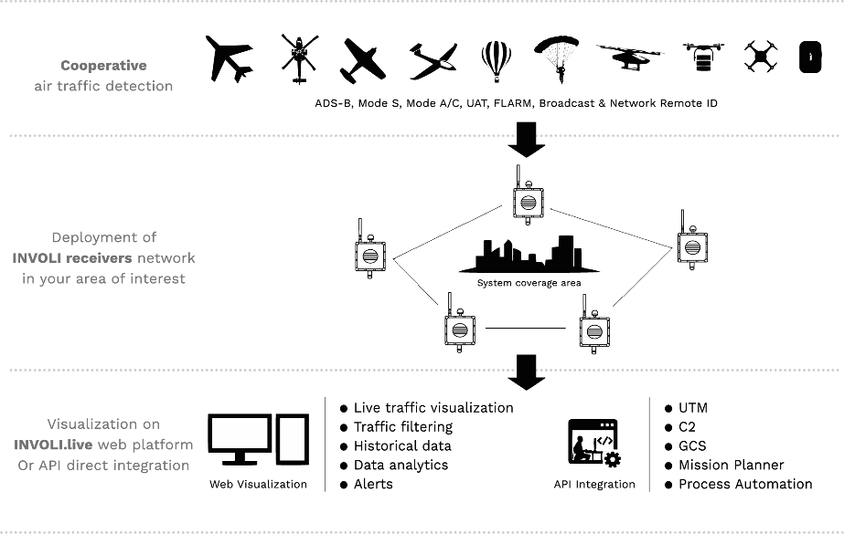
PRODUCTS AND SERVICES

G-1090
Cooperative air traffic receiver
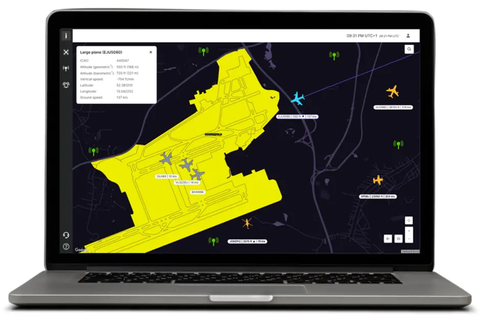
INVOLI.live
Air traffic visualisation platform and tools

REST API
Air traffic data injected in your software.
INVOLI G-1090
New generation of cooperative air traffic surveillance sensors

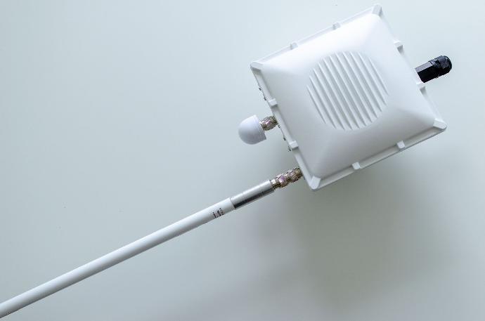
Wide range of detection capabilities
ADS-B, Mode S, Mode A/C, FLARM, UAT, Broadcast RID
Support SW-based Multilateration
INVOLI proprietary Multilateration algorithm are developed around the G-1090 receivers precise time stamps
Seamless integration with INVOLI.live
Each G-1090 Receiver is conceived to be directly integrated with INVOLI.live
Tailored to your needs
Each ADS-B receiver can be completed by a second antenna within the detection capabilities line: UAT, FLARM or Remote ID
Robust
Metal case, weatherproof IP66, surge protection, cavity filter for 1090 MHz frequency
Multiple connectivity options
The receivers can be powered through PoE or LTE connectivity (indoor and outdoor)
INVOLI.live
Cutting-edge air traffic platform


Data processing
Cloud-based platform that aggregates, processes and analyzes, large volumes of air traffic data detected by the G-1090 receivers
Network manager
Web interface to manage and monitor your entire G-1090 receivers network
Multilateration
In-house developed multilateration algorithms, which enhance the quality and reliability of the air traffic data
Live traffic visualisation display
Web interface to visualize in real-time manned and unmanned air traffic
Conflict alerts
Web interface to configure geofences and air traffic alerts
Traffic filtering
Web interface to filter air traffic data streams according to the signal type, or frequency
Data analytics
INVOLI can provide personalized data analytics reports leveraging air traffic data to make informed decisions
Network coverage map
Multi-layer map that provides an intuitive visualization of the surveillance coverage performance at different altitudes
Traffic density map
Multi-Layer map that provides air traffic density at different altitudes
REST API
Air traffic data and much more injected directly into your software

Example: integration of INVOLI air traffic data REST API into RigiTech "RigiCloud" drone flight management too

Application programming interface (API)
REST API to integrate air traffic data with 3rd party applications, UTM/U-space/USSP or DAA solutions
Plug and Play with our receivers
Adding supplementary receivers to your network will not need any further configuration or change to your REST API integration
Third-party stream integration
Integration of third party data streams (e.g. secondary radar or other data source) for seamless integration into your available data stream
Multilateration
In-house developed multilateration algorithms, which enhance the quality and reliability of the air traffic data
Coverage map
The live coverage of our system is also available via REST API, and it allows you to automatically monitor the status of our system
STRAIGHTFORWARD 3-STEP APPROACH
Plan
We help you define an air traffic detection strategy by analyzing you airspace, the infrastructure needed to meet your safety objective and budget your investments
Deploy & Connect
Install the receivers, they will automatically connect to INVOLI.live platform so you can instantly get access to safety-critical air traffic data
Operate
INVOLI.live offers you all the tools to control your airspace, improve safety and meet your compliance and audit obligations.
Get started today
Share your safety objective with us. We will provide you with a budgetary quotation.