Why Community Flight Trackers Are Great — But Not Enough for Drone Operations
If you’re into aviation — whether as a pilot, drone operator, or just a curious sky-watcher — chances are you’ve used tools like ADS-B Exchange, FlightRadar24, OGN, or even SafeSky. Honestly, we love them too. They’ve made air traffic more accessible, more open, and more exciting for everyone.
But as drone operators, there comes a point where awareness isn’t enough — what you really need is dependable, real-time data you can act on.
And that’s where INVOLI comes in.
🛩️ What Community Platforms Do Really Well
Let’s be clear: community flight trackers have done an amazing job.
They’ve built large-scale networks of air traffic receivers, often crowdsourced, and offer free or low-cost access to real-time(ish) air traffic data. In many regions, they’re surprisingly well covered and can show you a lot of what’s happening in the skies.
Some of them, like SafeSky, are even bringing that data into the cockpit to enhance pilot situational awareness — which is really great.
But here’s the thing: they weren’t built for drone operations.
🚁 Flying a Drone? Your Needs Are Different.
Flying a drone — especially Beyond Visual Line of Sight (BVLOS), or over sensitive areas like roads, people, or infrastructure — comes with different requirements.
It’s not just about seeing traffic.
It’s about knowing what’s missing, trusting the coverage, and being able to prove it.
Here are a few limitations when relying solely on community trackers for drone ops:
- Latency: Community data can be delayed. A few seconds matter when you’re making operational decisions in real time.
- Coverage: Even when platforms offer SLAs, they’re usually about server uptime — not about whether there's good receiver coverage where you fly. Why? Because the receivers are run by volunteers.
- Fragmented traffic detection: Most platforms focus on ADS-B (or ADS-B and UAT in the US). But in many countries — especially in Europe — many aircraft still fly with Mode S or Mode A/C transponders. Very few platforms offer reliable MLAT for these signals, resulting in inconsistent or partial coverage.
- No low-altitude assurance: Community trackers are mostly optimized for high-altitude, fixed-wing aircraft. They often miss helicopters, emergency responders, or low-flying general aviation aircraft — the exact traffic that might cross paths with your drone.
- Whitelisting: Some platforms even remove certain aircraft from the data they show — for example, by applying whitelisting filters. While this may be acceptable for public awareness tools, it's not okay for safety-critical drone operations, where every aircraft matters.
- Non-professional installation: Rooftop installs by volunteers are great for general coverage, but not for consistent low-altitude visibility. That’s why we work with telecommunication infrastructure providers to mount receivers on towers, poles, and high-quality structures — selected specifically to give optimal low-level performance.
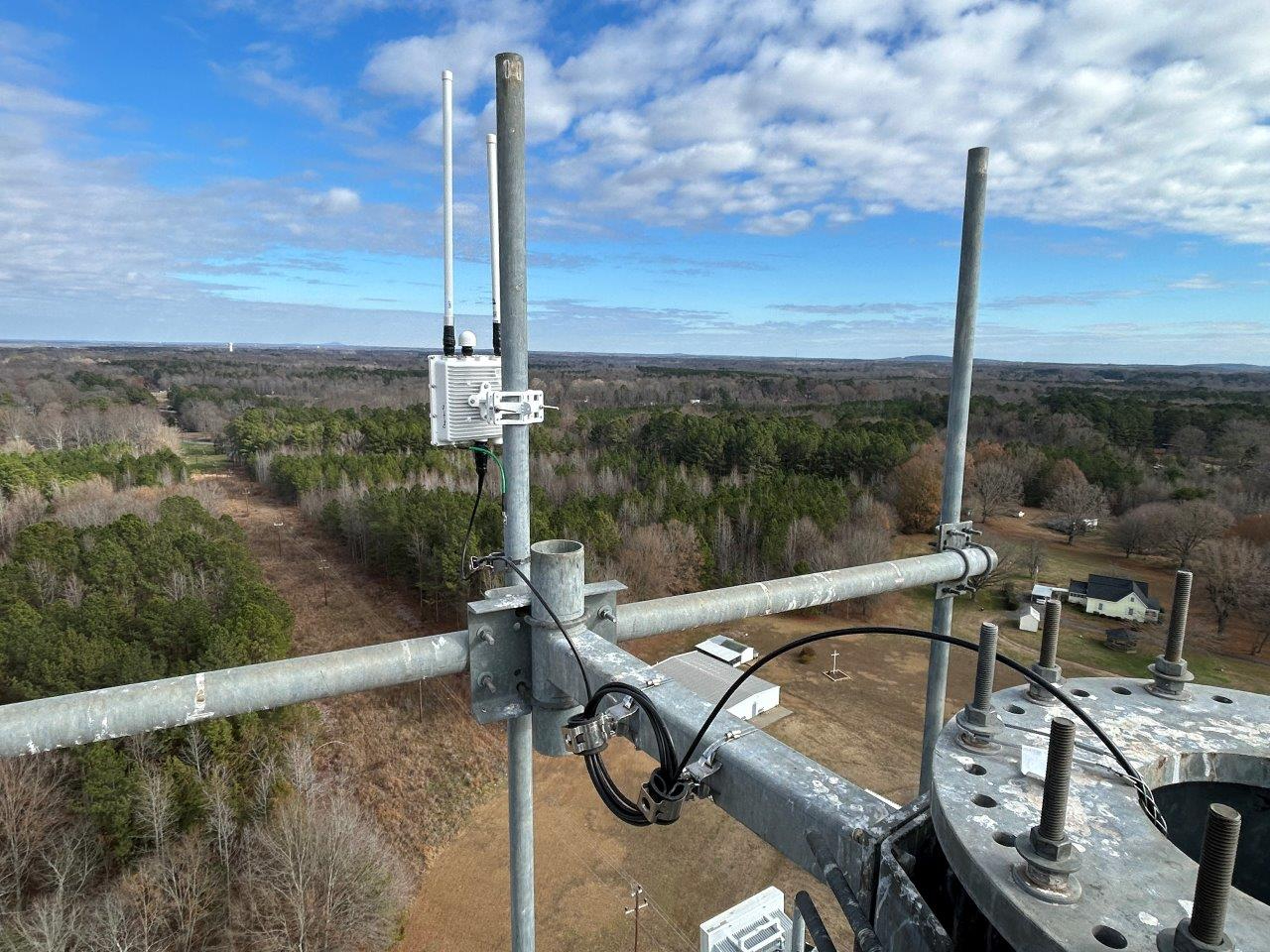
An INVOLI receiver installed over Crown Castle infrastructure at a height of 300 ft above ground, somewhere around Dallas TX. And the view from up here isn’t bad either!
Real-world reminder: During the California wildfires earlier this year, a firefighting Canadair aircraft collided with a drone (picture below).
Fortunately, the damage was limited — but it could have been catastrophic.
This kind of incident isn’t about bad intentions — it’s about a lack of real-time awareness and reliable airspace visibility.
Community flight trackers won’t save you in that moment. A safety-grade, low-altitude air traffic system might.
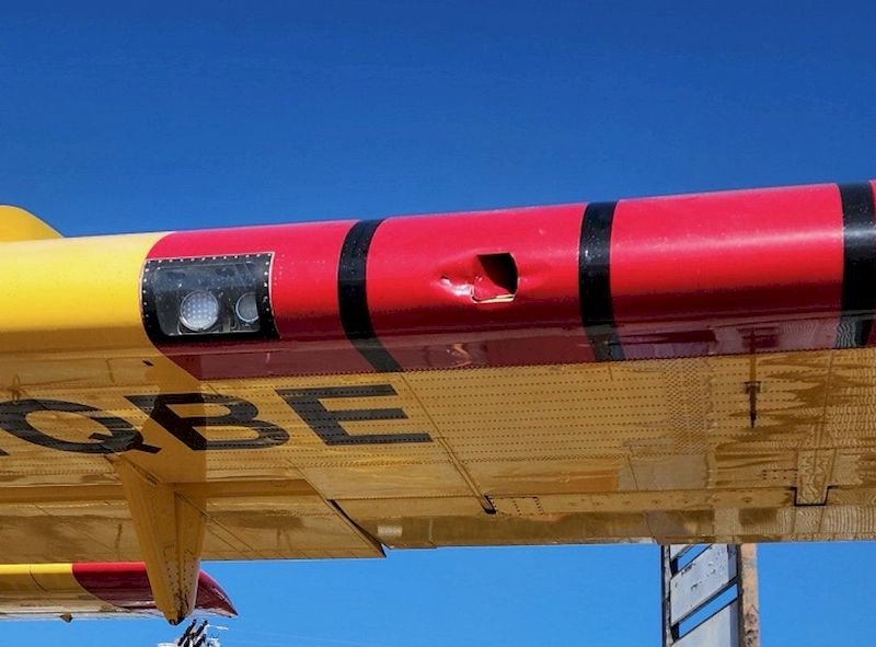
The drone's impact left a hole in the wing of the aircraft.
🔍 What Makes INVOLI Different
We didn’t set out to build a flight tracker.
We built a turnkey solution to help drone operators fly safely — with real-time, reliable, and meaningful air traffic data.
Here’s how:
- 🛰️ Multi-protocol detection: Our receivers detect ADS-B, Mode S, Mode A/C, UAT, FLARM (soon also ADS-L), and Remote ID signals. We provide the right detection capabilities based on the specific needs and technologies used in your local airspace, so you only get what’s relevant.
- 🌍 Professional-grade infrastructure: We install our receivers where they’re needed most — using telecom towers and strategic assets, not rooftops.
- 🔁 Live coverage check: Our platform, INVOLI.live, lets you check coverage in real time — so you always know what’s working and what’s visible before your flight.
- 🧰 Turnkey deployments: Need a specific area covered? We can simulate expected coverage before deployment and measure it after installation, ensuring your corridor or region is ready to support safe drone operations.
- 🧭 What if there's no coverage in your area? No problem. Thanks to our tower company partnerships and the fact that we own our receiver production end-to-end, we can deploy full low-altitude coverage over areas as large as Dallas in just 2–3 months.
- 📋 Safety Management System (SMS): We don’t just deliver data — we manage it under an aviation-grade Safety Management System, with formal procedures, ConUse documentation, monitoring tools, and fallback mechanisms in case something isn’t working as expected.
- 📘 Aligned with standards: INVOLI isn’t just building systems — we’re also helping shape the rules. Our CEO, Manu Lubrano, is co-leading the ASTM F3623-23 standard, which defines performance requirements for ground-based surveillance used in drone operations.
- ⚙️ Built with drone operators: Every feature we roll out is based on direct conversations with operators, shaped by real-world BVLOS and DFR needs.
- 🛫 Trusted by regulators: We’re working closely with Civil Aviation Authorities around the world to push the system toward certified-grade safety. We call this "Qualified Data" — it sits between crowdsourced feeds and fully certified radar. It’s practical, scalable, and reliable enough to support real drone ops.
📈 A Sign You’re Growing
One thing we’ve seen again and again?
Drone operators often come to us after relying on community platforms — usually after a serious discussion with their local CAA.
That’s often the moment they realize:
“Okay… we need something more solid, more dependable — something built for real drone ops.”
We see that moment as a milestone.
Needing INVOLI means your company is growing, scaling, and taking safety seriously.
It means you're moving from experimentation to real-world drone operations — BVLOS, DFR, infrastructure inspection, or logistics.
And that’s where we come in.
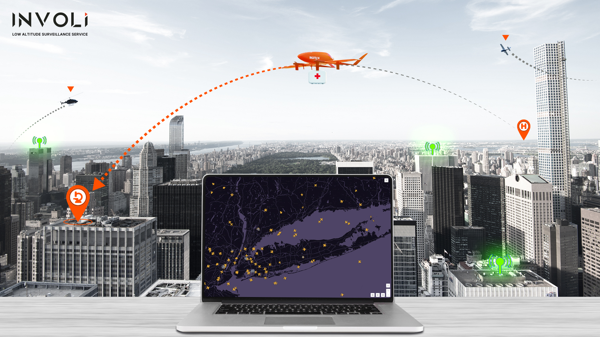
The INVOLI.live platform for visualization of data coming from INVOLI's network of receivers
💬 Not a Competition. A Complement.
We’re not here to replace community trackers.
We love what they’ve done — and in fact, we’re building complementary partnerships to make aviation even more transparent and connected.
But INVOLI is built for another mission.
Not just to see the sky — but to increase safety and help you scale your operations with confidence.
TL;DR: If You’re Making Real Decisions, You Need Real Data.
Community trackers are a great place to start.
But if you're flying drones — especially BVLOS or in complex environments — you need more.
✅ Real-time.
✅ Multi-protocol.
✅ Verifiable.
✅ Professionally installed.
✅ Deployed fast, with precision.
✅ Supported by SMS & safety procedures.
✅ Built for operators.
✅ Recognized by regulators.
✅ Aligned with international standards.
That’s INVOLI — your partner for safer skies.